
![]()
![]()

Coordinate Transformations
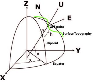
GNSS analysis is performed with respect to a geocentric Cartesian terrestrial reference frame embodied in a series of International Terrestrial Reference Frame definitions, the latest being ITRF2014. The IGS maintains a reference frame that is consistent and aligned with the ITRF, the latest being IGS14. Historically, the Earth’s figure has been approximated by an oblate ellipsoid of revolution fixed to the Earth, which is uniquely defined by two parameters typically expressed by the semimajor axis aand inverse flattening (1/f). These purely geometric parameters, supplemented by the specification of the ellipsoid’s center, its orientation and scale define a horizontal geodetic datum (Leick, 2004). The familiar relationship between “geodetic” coordinates (, , h), (latitude, longitude, height) and spatial ITRF (X,Y,Z) coordinates is
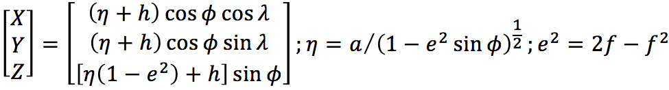
where eis ellipsoid’s eccentricity. The geodetic representation allows GPS positions to be combined with historic geodetic observations (triangulation, trilateration) originally defined with respect to various geodetic datums after appropriate transformations have been applied (Soler and Hothem, 1989).
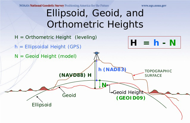
Values for the ellipsoidal parameters (a, f) used for GPS analysis are usually taken from a standard coordinate system for the Earth that, historically, served both as a reference ellipsoid (datum) and an approximation to the gravitational equipotential surface that defines the geoid (nominal sea level – section 7.2). The geocentric Geodetic Reference System GRS80 included the following parameters: the ellipsoid’s semi-major axis or Earth’s equatorial radius a=6378137 m and the flattening factor 1/f=298.257222101. The GRS80 physical constants included the geocentric gravitational constant GM=3.986005 x 10¹⁴m3/s2, the dynamical form factor J2=1.8263 x 10⁻³, and nominal mean Earth’s angular velocity w=7.292115 x 10⁻⁵rads-1. At one point, the World Geodetic System 1984 (WGS 84) ellipsoid, which is the datum for GPS maintained by the U.S. Department of Defense, was defined to be equivalent to the GRS80 ellipsoid. The WGS84 is globally consistent within ±1 m, compared to current realizations of the ITRS, the ITRF, which are internally consistent at the cm level. Therefore, the U.S. Department of Defense has kept WGS84 consistent with the ITRF. The current WGS84 ellipsoidal parameters are the semi-major axis a=6378137 (same as GRS80) and a slightly modified flattening 1/f=298.257 223 563.
The CSRC is concerned with the transformation of ITRF coordinates to a North America fixed reference frame maintained by the U.S. National Geodetic Survey (NGS), referred to as National Geodetic Datum 83 (NAD83) of multiple versions, the latest being NAD83(2011). The NGS maintains several program that perform the transformations from ITRF to NAD. The Horizontal Time-Dependent Positioning (HTDP– note that this is a beta page that includes transformations for ITRF2014) software also allows coordinates transformation from one date to another, which is useful in tectonically deforming regions such as California. The NGS Coordinate Conversion and Transformation Tool (NCAT) is also useful.
![]()
In February 2018, the CSRC published a new geodetic datum for California called “CSRS Epoch 2017.50 (NAD83)” under a Caltrans contract to SIO/SOPAC. The new epoch-date coordinates have been embedded in the RTCM 3.0 data streams since March 1, 2018.
June 16: The CSRC 2017.50 map is now accessible via QR code. Use the QR code below. (If needed, instructions are available here.)