


Hydrology - Groundwater Storage
05/15/2023: Water storage product for Western North America updated until end of March 2023 (2006.042_2023.208)
12/07/2022: Water storage product for Western North America updated until end of August 2022 (2006.042 to 2020.625)
Download from SOPAC: Water Storage Product (Username: anonymous; Password: your e-mail address)
Download from CDDIS: Water Storage Product (Register for NASA Earthdata login)
Download: Video by Donald Argus
ReadMe file.
Background
The solid Earth responds elastically to changes in mass surface load, which allows us to infer changes in total water at Earth's surface as a function of location and time. The spatial resolution is only limited by the spacing of the GNSS stations. A spacing of 10 km would be sufficient to determine mass change in individual watersheds and ice basins. See project's Algorithm Theory Basis Document ATBD for more information.
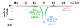
(Green curve) Vertical motion in elastic response to unloading of a disk with a radius of 14 km and a water thickness of 1 m. This disk has the same area as a pixel at 36°N for which we estimate water thickness for (1/4° latitude by 1/4° longitude). (Blue curve) Vertical motion in elastic response to unloading of a disk with a radius of 7 km and a water thickness of 4 m. (Pink curve) Vertical motion that would be inferred by GRACE is approximated by a Gaussian distribution with a halfwidth of 200 km. “Gt” is gigatons (1012 kg).
Our hydrology products have a latency of 2 months and a spatial resolution of 100km (about 1 degree or less depending on the spacing of the GNSS stations), therefore, complementing GRACE estimates of Total Water Storage with a spatial resolution of about 3 degrees.
Product Description
Changes in components of water storage are provided every two months in text files representing the seen contributions to the water storage product. The first two columns in each file are latitude and longitude. ReadMe file.
Data files and grids: http://garner.ucsd.edu/pub/measuresESESES_products/WaterStorage/
Change in total water storage inferred from GPS – “water.gps”
column 3- equivalent water thickness (mm); column 4- uncertainty in equivalent water thickness (mm)
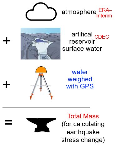
Change in equivalent water thickness – “atmosphere”
column 3- change in equivalent water thickness (mm)
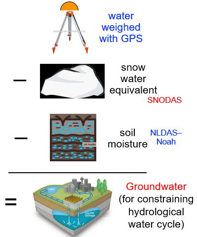
Change in snow water equivalent (SWE) – “snow”
column 3- change in snow water equivalent (mm)
Snow depth and snow water equivalent (SWE) data are available from NOAA’s National Weather Service's National Operational Hydrologic Remote Sensing Center (NOHRSC) SNOw Data Assimilation System (SNODAS).
Change in soil moisture content (SMC) – “soil”
column 3- change in soil moisture (mm)
NLDAS_NOAH is a monthly climatology data set contains a series of land surface parameters, including Soil Moisture Content (SMC), simulated from the Noah land-surface model (LSM) for Phase 2 of the North American Land Data Assimilation System (NLDAS-2).
Change in artificial reservoir surface water – “reservoir”
column 3- change in artificial reservoir surface water (mm)
These hydrological data are from the California Data Exchange Center (CDEC) Weather Gauging Stations, including automatic snow reporting gages for the Cooperative Snow Surveys Program and precipitation and river stage sensors for flood forecasting.
Change in total mass – “mass”
Total mass = water.gps + reservoir + atmosphere
column 3- change in soil moisture (mm);
Change in water in the ground not in hydrology models – “ground”
Inferred to be water.gps - snow - soil moisture
column 3- change in water in the ground not in hydrology models (mm); column 4 - uncertainty in equivalent water thickness (mm)
Alternate retrieval of product:
Use wget command below to access data or contact: Donald.F.Argus@jpl.nasa.gov
wget -r -np -nH --cut-dirs=5 -R "index.html*"
http://sideshow.jpl.nasa.gov/pub/usrs/argus/measures/west.us/cmby.2022aug
References
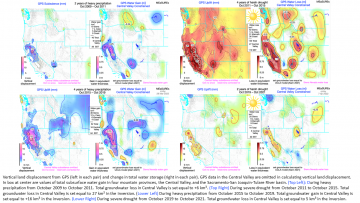
Argus, D.F., Landerer, F.W., Wiese, D.N., Martens, H.R., Fu, Y., Famiglietti, J.S., Thomas, B.F., Farr, T.G., Moore, A.W. and Watkins, M.M. (2017), Sustained water loss in California’s mountain ranges during severe drought from 2012 to 2015 inferred from GPS, Journal of Geophysical Research: Solid Earth, 122. https://doi.org/10.1002/2017JB014424.