

![]()
![]()

CSRC Height Modernization Projects
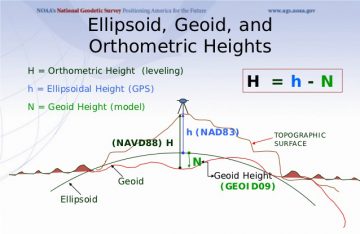
The CSRC conducted a series of Height Modernization and subsidence projects in collaboration with the National Geodetic Survey and California State and County jurisdictions with contracts to the private sector. These projects from 1999-2007) established geodetic monuments (markers) throughout the State in order to estimate orthometric heights from ellipsoidal heights and geoid models, rather than more expensive spirit leveling (see Figure). The surveys were tied to the CSRS and NSRS through continuous GPS stations operating at the time. The projects were done in accordance with the CSRC Master Plan. The data and metadata from these projects collected through the Pocket GPS Manager (PGM) and the geodetic solutions can be found here.
| Yolo County Subsidence Projects (1999, 2002, 2005) |
| The Yolo County projects were designed and observed to provide a basis for monitoring subsidence in the county. It was accomplished to NGS Height Modernization guidelines. The project was first observed in 1999. It included stations selected from the I-80 corridor north to the Yolo- Colusa County line. It was bounded on the east by the Sacramento River and on the west along the foothills in western Yolo County.
The project was re-observed in 2002 as suggested in a series of recommendations to the county following the 1999 project observations. The small portion of the county south of the I-80 corridor was added to the project. In addition the county was approached by the City of Sacramento to include some additional stations to the network. All of these stations were included in the 2002 project. Subsidence was noted, primarily along the I-5 corridor south to the Highway 113 intersection and then south along the Highway 113 corridor into Davis. The portion of the county south of the I-80 corridor was part of an earlier campaign survey, the Sacramento-San Joaquin Delta project observed in 1997. In the summer of 2005 the county was observed once again. All three projects (1999, 2002 and 2005) were funded by several agencies, primarily the California Department of Water Resources. Observers represented several different Federal, State, County and City agencies. Contributed by: Don Donofrio |
| South San Francisco Bay Height Modernization Project 2003 |
| The South San Francisco Bay Height Modernization Project is a combined horizontal and vertical control survey carried out by the CSRC as a 2-centimeter Height Modernization project, and was submitted to NGS for blue-booking in the late autumn of 2003. The horizontal accuracy of this network is Order B. The private contractor for both the GPS and leveling portions of this network was Johnson-Frank and Associates.
The South San Francisco Bay control network is located on both sides of the southern San Francisco Bay, California, extending from the Pacific Coast on the west to Mount Hamilton the east, and from Angel Island on the north to the southern limits of the City of San Jose on the south. The area of the network comprises about 1700 square miles. This project is the culmination of a process begun in 1996. In 1996 NGS, in cooperation with several other agencies, including the Bay Conservation and Development Commission, the California Coastal Commission and the California State Lands Commission, performed the first demonstration project for Height Modernization. The project encompassed the central portion of the San Francisco Bay bounded by San Leandro to Berkeley on the east and Daly City to San Rafael on the west. Over the next several years the project was extended through the north Bay, San Pablo and Suisun Bays, and throughout the San Joaquin/Sacramento River Delta area. This CSRC project completes the Height Modernization efforts for the overall Bay/Delta area. Contributed by: Mike Potterfield |
| Tuolomne County Height Modernization Project 2003 |
| The South San Francisco Bay Height Modernization Project is a combined horizontal and vertical control survey carried out by the CSRC as a 2-centimeter Height Modernization project, and was submitted to NGS for blue-booking in the late autumn of 2003. The horizontal accuracy of this network is Order B. The private contractor for both the GPS and leveling portions of this network was Johnson-Frank and Associates.
The South San Francisco Bay control network is located on both sides of the southern San Francisco Bay, California, extending from the Pacific Coast on the west to Mount Hamilton the east, and from Angel Island on the north to the southern limits of the City of San Jose on the south. The area of the network comprises about 1700 square miles. This project is the culmination of a process begun in 1996. In 1996 NGS, in cooperation with several other agencies, including the Bay Conservation and Development Commission, the California Coastal Commission and the California State Lands Commission, performed the first demonstration project for Height Modernization. The project encompassed the central portion of the San Francisco Bay bounded by San Leandro to Berkeley on the east and Daly City to San Rafael on the west. Over the next several years the project was extended through the north Bay, San Pablo and Suisun Bays, and throughout the San Joaquin/Sacramento River Delta area. This CSRC project completes the Height Modernization efforts for the overall Bay/Delta area. Contributed by: Mike Potterfield |
| Southern California Height Mod. Differential Leveling 2003 |
| This project was undertaken by CSRC to establish a North American Vertical Datum of 1988 (NAVD88) differential elevation on a selection of continuous GPS (CGPS) stations that are part of the Southern California Integrated GPS Network (SCIGN) array. (Further work is currently being done in other areas of the State but this section will concentrate on the first leveling project completed, which was in Southern California). The purpose of this project is to establish an orthometric height on the base of the preamplifier of the antenna (BPA) and the geodetic reference mark (GRM) at each selected station which then can be used as vertical control in an adjustment to establish GPS derived orthometric heights (+/- 2cm) on all the CGPS stations in Southern California (the 10 southernmost counties). This process is to help fulfill the CSRC's function of providing vertical spatial reference to surveyors and other geodetic users in the State of California.
Related documents
|
| Glenn County Subsidence Project 2004 |
| The Glenn County project was developed to serve as a basis for monitoring subsidence in the county. It was observed to NGS Height Modernization guidelines. The project was observed in the spring of 2004. It is presently being processed by CSRC before submission to NGS.
The project was funded primarily by the California Department of Water Resources. Observers represented State and County agencies, an irrigation district and civilian member of the county water advisory board. Contributed by: Don Donofrio |
| Northern California Height Mod. Project 2004 (PGM) |
| This project consisted of 33 stations around Folsom Lake, east of Sacramento. The project was bounded by Caltrans North Region Ht Mod stations on all four sides. 12 new stations were established in the project. The purpose of the project was to provide a uniform vertical reference system constrained to NAVD88 and to support GPS-controlled aerial photography of the lake and environs. The project is bounded on the east at Long. 120-50, on the west at Long. 121-18, on the north at Lat. 38-55, and, on the south at Lat. 38-29. There were six Primary Base Stations (PBS) including two CGPS sites. All but one were PBS sites used by Caltrans in its North Region Project. The sixth PBS site was a new station near the center of the project. In additionto the 32 project stations, USBR had asked that four additional stations be observed around the lake shoreline. These stations were selected to ensure line-of-sight around the lake for ongoing terrestrial operations and will be established by USBR.
View the complete status of this campaign Access campaign images (restricted access) and RINEX data uploaded via PGM Contributed by: Don Donofrio |
| Central Coast Height Modernization 2007 |
|
| The Northern San Joaquin Valley Height Modernization Project 2006 |
This project encompassed the entire San Joaquin Valley of California, from Modesto in the North to Bakersfield in the South. The private contract for this project was awarded to Condor Earth Technologies in May of 2004. In addition to the extensive network observed by Condor, the California Department of Transportation (Caltrans) contributed 3 GPS subnetworks attached to the overall scope of the network - one project near Los Banos, another near Visalia, and an earthquake study in the vicinity of San Luis Obispo, which was carried out to estimate the displacements resulting from the 22 December 2003 Mw6.5 San Simeon earthquake near Paso Robles. In addition to the GPS networks, Caltrans has run more than two hundred kilometers of precise leveling across the valley floor. The active geology of this survey includes not only the San Simeon earthquake, but also vertical subsidence of more than a meter over a period of 12 years in the vicinity of Chowchilla. Because the observations used to construct this network took place over a period of more than a year, the project has been modeled as a multi-epoch network, with adjusted velocities and displacements being estimated for four different temporal epochs. The project offered substantial challenges in virtually every aspect of geodetic surveying in California, including adjusted geoid models, adjusted velocity models, earthquake models contributed by the Southern California Earthquake Center and adjusted by the CSRC and complex constraints tied directly into the California Spatial Reference System (CSRS) network of continuous GPS stations. (Contributed by: Mike Potterfield - modified by Yehuda Bock)
|
![]()