

![]()
![]()

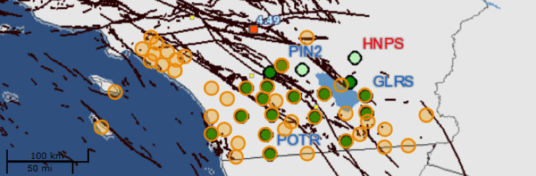
SOPAC GNSS Network in Southern California
SOPAC maintains an active continuous GNSS network of 48 stations in southern California (Table), as part of the California Real Time Network (CRTN) The first stations were installed in 1991 as part of the Permanent GPS Geodetic Array project (PGGA – Bock et al., 1997), followed by the Southern California Integrated GPS Network project (SCIGN), starting in 1997. A number of stations were later transitioned to the Plate Boundary Observatory (PBO), starting in 2004. All stations have been upgraded to high-rate sampling (1Hz) and real-time data transmission, starting ~2010. The stations, including those operated by UNAVCO’s Plate Boundary Observatory (PBO) and the USGS Pasadena Office, make use of UCSD’s HPWRENcommunications backbone. Data from the Orange County Real Time Network (OCRTN) stations are transmitted through a dedicated radio network installed by SOPAC to the Orange County Department of Public Works and re-transmitted to SOPAC via the Internet.
Parts of the network have been upgraded to seismogeodetic capability (Bock et al., 2011) with SIO Geodetic Module and MEMS Accelerometer packages (GAPs– Saunders et al., 2016) and to GPS meteorology (Moore et al., 2015) with SIO MEMS Met packages.
References
Bock, Y., D. Melgar, B. W. Crowell (2011), Real-Time Strong-Motion Broadband Displacements from Collocated GPS and Accelerometers, Bull. Seismol. Soc. Am., 101, 2904-2925, doi: 10.1785/0120110007.
Bock Y., S. Wdowinski, P. Fang, J. Zhang, S. Williams, H. Johnson, J. Behr, J. Genrich, J. Dean, M. van Domselaar, D. Agnew, F. Wyatt, K. Stark, B. Oral, K. Hudnut, R. King, T. Herring, S. DiNardo, W. Young, D. Jackson, and W. Gurtner (1997), Southern California Permanent GPS Geodetic Array: Continuous measurements of crustal deformation between the 1992 Landers and 1994 Northridge earthquakes, J. Geophys. Res., 102, 18,013-18,033.
Moore, A.W. et al. (2015), National Weather Service Forecasters Use GPS Precipitable Water Vapor for Enhanced Situational Awareness during the Southern California Summer Monsoon, Bull. Amer. Meteorol. Soc. 96(11), 1867-1877, doi:10.1175/BAMS-D-14-00095.1.
Saunders, J. K., D. E. Goldberg, J. S. Haase, D. G. Offield, Y. Bock, D. Melgar, J. Restrepo, R. B. Fleischman, A. Nema, J. Geng, C. Walls, D. Mann, G. Mattioli (2016), Seismogeodesy using GNSS and low-cost MEMS accelerometers: perspectives for earthquake early warning and rapid response, Bull. Seismol. Soc. Am., 106, 6, pp. 2469–2489, doi: 10.1785/0120160062.
![]()