

![]()

Welcome to the Scripps Orbit and Permanent Array Center
Researching, analyzing and archiving high-precision geodetic and seismic data for the study of earthquake and tsunami hazards, tectonic plate motion, crustal deformation and structural monitoring
Scripps Institution of Oceanography's Orbit and Permanent Array Center (SOPAC) has served a large community of users, starting in 1991, with a focus on the analysis and archiving of precise GPS data/metadata and data products. Today, SOPAC also refers to our research group, using geodetic and seismic data for a wide range of projects in geodesy, geophysics, surveying and engineering.
Award 9/21/2023: SIO has been chosen as one of 4 institutions to receive an FY23 Geospatial Modeling Competition Award by NOAA's National Geodetic Survey (NGS) (Yehuda Bock, Principal Investigator). SIO is receiving $1,300,000 annually for a potential total of $6,500,000 over a 5-year period for a project titled "NSRS Intra-Frame Deformation Model and New SIO Geodesy Program." The primary objectives of this project are to create a formal geodesy program in support of the nationwide deficiency of geodesists and to modernize geodetic models for the NSRS.
Update 9/18/2023: The NOTA stations are now mostly available with reasonable latency. However, all USGS stations (see columns I in CRTN station spreadsheet - http://sopac-csrc.ucsd.edu/wp-content/uploads/2023/08/CRTN_Access_2017.50_GNSS_ZONES_08-10-2023_Public.xlsx ) are not yet available. Kudos to Charlie Sievers at EarthScope.
Alert 9/9/2023: Connection to NOTA stations restored - however, latency has grown
Alert 9/5/2023: Until further notice, all connections to NOTA (PBO) real-time stations are down today, September 5, 2023, since ~15:00 UTC (08:00 PDT). According to EarthScope (formally UNAVCO), they migrated their real time services into the cloud earlier today as part of shutting down the Boulder, CO data center. "The cloud service worked fine in testing, but under load the bkg casters are having issues ..., the RTCM casters are currently showing latencies that sometimes get as long as 3 minutes. I'm actively working through them to resolve the issues." The affected stations can be identified on the CRTN status map. We are sorry for the inconvenience and will keep you updated.
Current SOPAC News
- New Publication: "Defining the Coseismic Phase of the Crustal Deformation Cycle with Seismogeodesy," by Dorian Golriz, Yehuda Bock & Xiaohua Xu (2021), J. Geophys. Res.: Solid Earth, 126, e2021JB022002. https://doi.org/10.1029/2021JB022002
- New Publication: "Coevolving early afterslip and aftershock signatures of a San Andreas fault rupture" by Junle Jiang, Yehuda Bock and Emily Klein (2021), Sci. Adv., 7: eabc1606, https://advances.sciencemag.org/content/7/15/eabc1606
- Review Paper: Yehuda Bock and Shimon Wdowinski (2020)," GNSS Geodesy in Geophysics, Natural Hazards, Climate, and the Environment," in Position, Navigation, and Timing Technologies in the 21st Century: Integrated Satellite Navigation, Sensor Systems, and Civil Applications, IEEE, 2021, 741-820, doi: 10.1002/9781119458449.ch28.
- Klein et al. (2019) research is highlighted in UNAVCO's Geodetic Science Snapshot "Capturing California’s Crustal Motion with Geodesy"
- New Publication: "Transient deformation in California from two decades of GPS displacements: Implications for a three‐dimensional kinematic reference frame" by Emily Klein, Yehuda Bock, Xiaohua Xu, David Sandwell, Dorian Golriz, Peng Fang and Lina Su, Journal of Geophysical Research Solid Earth, https://doi.org/10.1029/2018JB017201
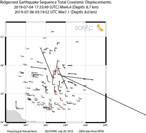
- SOPAC computed coseismic offsets for the Ridgecrest earthquakes July 4 and 6, 2019.
- Click here for more SOPAC news
Currently, SOPAC provides several community services:
- SOPAC GARNER archive of GNSS, seismic and meteorological data/metadata and data products (username: anonymous; password: your e-mail address)
- International GNSS Service Global Data and Analysis Center, since the inception of the IGS.
- California Spatial Reference Center (CSRC)
- California Real Time Network (CRTN)
SOPAC maintains an Oracle 12 database that supports user access via web services and APIs, such as SCOUT (an ITRF coordinates generator from RINEX data), Site Information Manager (SIM – GNSS metadata), SECTOR (utility to access epoch-date coordinates for reference stations), and a utility to check for unused 4-character GNSS site codes.
SOPAC also maintains the GPS Explorer data portal for the NASA MEaSUREs “Solid Earth Science Data Records (SESES)” project in collaboration with the Jet Propulsion Laboratory in Pasadena, California.
Data and data products from the SOPAC GARNER archive may be retrieved via ftp://garner.ucsd.edu and http://garner.ucsd.edu (username: anonymous; password: your e-mail address). Frequently used directories include: combinations, gamit, hfiles, met, ppp, products, rinex, rinex_highrate, timeseries. Archive metrics are provided in several categories and formats.
Please acknowledge usage of SOPAC data and/or data products in your publications, applications and products. Access to the SOPAC archive is intended for non-commercial users but there are no user fees and there is significant usage by the private sector.
Yehuda Bock, Director
Peng Fang, Assistant Director
Rooms 4208, 4108
8785 Biological Grade
Institute of Geophysics and Planetary Physics
Scripps Institution of Oceanography
La Jolla, CA 92093-0225
Tel: (858) 534-5292, (858) 534-2445
E-mail: ybock-at-ucsd.edu; pfang-at-ucsd.edu
Click here for the full personnel list.
![]()
In Memoriam: John Canas (October 5, 2021)
SOPAC/CSRC Director gave presentation "Using GNSS and InSAR to Maintain a Dynamic Vertical Datum" at 61st Meeting of the Civil GPS Service Interface Committee, September 21, 2021
SOPAC/CSRC awarded Caltrans contract to study dynamic geodetic datums (2020-2021)
Update August 30, 2019: July 4,6 2019 Ridgecrest earthquakes
Coseismic offsets (corrected 11/4/2019)
Epoch 2019.55 coordinates for affected stations
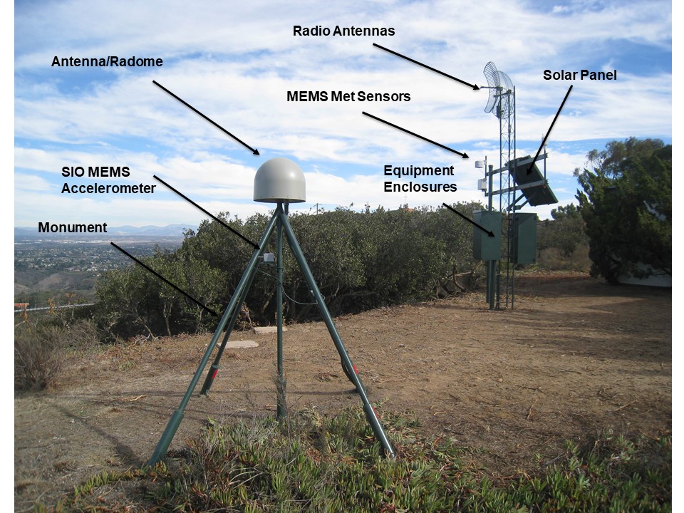
SOPAC computed coseismic offsets using the GAMIT/GLOBK software with 30s data from 109 continuous GNSS stations within a radius of 160 km from the epicentral region.
click here to learn more.