


GNSS Seismology and Seismogeodesy
Download from SOPAC: EarthquakeDisplacements (Username: anonymous; Password: your e-mail address)
Download from CDDIS: EarthquakeDisplacements (Register for NASA Earthdata login)
Download: Video by Dorian Golriz
This product consists of an archive of 1-5 Hz GNSS displacements ("GNSS seismology") and 100 Hz seismogeodetic displacement and velocity waveforms ("Seismogeodesy") for a catalog of historical earthquakes. High-rate data are useful for a range of applications such as modeling coseismic & postseismic slip to understand their underlying processes, determining the transition from coseismic to early postseismic deformation (Jiang et al., 2020; Golriz et al., 2021), and earthquake and tsunami early warning systems.
Background
Continuous GPS networks have been developed since the early 1990's to observe crustal deformation at plate boundaries with higher temporal resolution compared to GPS surveys (campaigns). Other applications became apparent, for example, GNSS meteorology. Initially, cGNSS networks operated at a 15-30s sampling rate and data were downloaded once per day. These data were used to create daily GNSS displacement time series some of which now extend nearly 30 years. High-rate data, ≥ 1 sample per second (1 sps – also expressed as “1 Hz”, 10 sps = 10 Hz), were first applied to study crustal deformation by deploying small-aperture kinematic surveys of locked or freely slipping (creeping) geological faults (Genrich and Bock 1992), and subsequently for dynamic applications such as movement of ice sheets for climate studies, georeferencing of airborne lidar surveys, GPS-Acoustics (GPS-A) for seafloor positioning and engineering seismology. In the early 2000's, cGNSS networks began to be upgraded to high-rate observations and streamed and processed in real-time. "GNSS seismology" provides coseismic displacements, both static (permanent) and dynamic, during earthquake shaking (Bock et al. 2000; Nikolaidis et al. 2001; Larson et al., 2003; Genrich and Bock 2006; Langbein and Bock 2004; Langbein et al., 2006; Larson 2009). A comprehensive archive of high-rate GNSS displacements, in seismic format, for 29 earthquakes from 2003-2018 with moment magnitudes of Mw 6.0-9.0 is described by (Ruhl et al. 2018). We also maintain an archive of these GNSS displacement and add new significant earthquakes to this historical record, as they occur or are reprocessed.
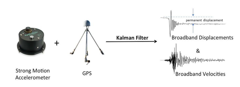
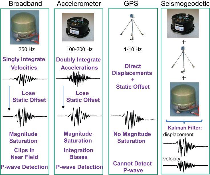
We also archive seismogeodetic displacement and velocity waveforms, a product of an optimal combination of high-rate GNSS and seismic data (Bock et al. 2011; Saunders et al., 2016). Seismogeodesy provides a real-time broadband seismometer that does not clip in the near field of significant earthquakes, a measure of permanent displacement for rapid magnitude estimation, and an instrument that does not experience magnitude saturation for large earthquakes (Goldberg and Bock, 2018).
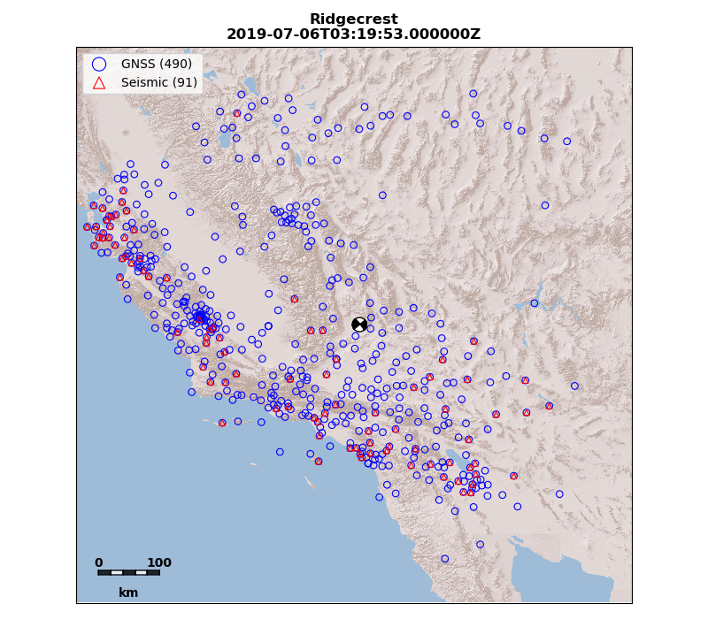
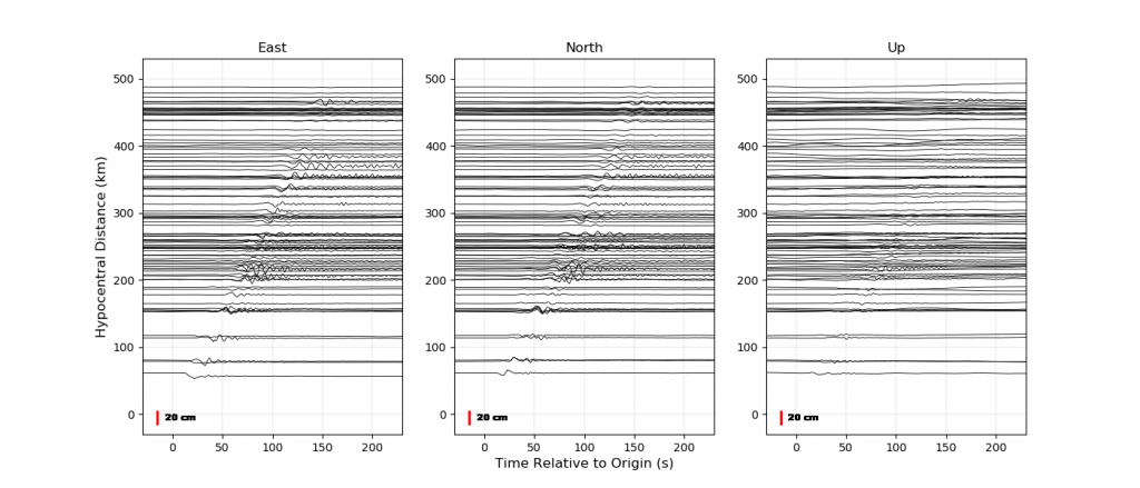
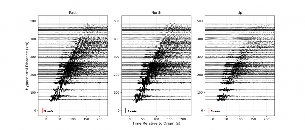
Seismogeodetic waveforms for the July 6, 2019 Mw7.1 Ridgecrest earthquake
References
Bock, Y., D. Melgar, B. W. Crowell (2011), Real-Time Strong-Motion Broadband Displacements from Collocated GPS and Accelerometers, Bull. Seismol. Soc. Am., 101, 2904-2925, doi: 10.1785/0120110007.
Genrich, J. F. and Y. Bock (1992), Rapid resolution of crustal motion at short ranges with the Global Positioning System, J. Geophys. Res., 97, 3261-3269.
Genrich, J. F. and Y. Bock (2006), Instantaneous geodetic positioning with 10-50 Hz GPS Measurements: Noise characteristics and implications for monitoring networks, J. Geophys. Res., 111, B03403, doi:10.1029/2005JB003617.
Goldberg, D., Y. Bock (2017), Self-contained local broadband seismogeodetic early warning system: Detection and location, J. Geophys. Res. Solid Earth, 122(4), 3197-3220, doi:10.1002/2016JB013766.
Golriz, D, Y. Bock & X. Xu (2021), Defining the Coseismic Phase of the Crustal Deformation Cycle with Seismogeodesy, J. Geophys. Res.: Solid Earth, 126, e2021JB022002. https://doi.org/10.1029/2021JB022002
Jiang, J., Y. Bock and E. Klein (2021), Coevolving early afterslip and aftershock signatures of a San Andreas fault rupture, Sci. Adv., 7: eabc1606, https://advances.sciencemag.org/content/7/15/eabc1606
Langbein, J. and Y. Bock (2004), High-Rate Real-Time GPS Network at Parkfield; Utility for Detecting Fault Slip and Seismic Displacements, Geophys. Res. Lett., 31, doi:10.1029/2003GL019804.
Langbein, J., Murray, J. R., & Snyder, H. A. (2006), Coseismic and initial postseismic deformation from the 2004 Parkfield, California, earthquake, observed by Global Positioning System, electronic distance meter, creepmeters, and borehole strainmeters. Bulletin of the Seismological Society of America, 96(4B), S304-S320.
Larson, K. M., Bodin, P., & Gomberg, J. (2003), Using 1-Hz GPS data to measure deformations caused by the Denali fault earthquake. Science, 300(5624), 1421-1424.
Larson, K. M. (2009), GPS seismology. Journal of Geodesy, 83(3-4), 227-233.
Nikolaidis, R., Y. Bock, P. J. de Jonge, P. Shearer, D. C. Agnew, and M. Van Domselaar (2001), Seismic wave observations with the Global Positioning System, J. Geophys. Res., 106, 21,897-21,916.
Saunders, J. K., D. E. Goldberg, J. S. Haase, Y. Bock, D. G. Offield, D. Melgar, J. Restrepo, R. B. Fleischman, A. Nema, J. Geng, C. Walls, D. Mann, G. Mattioli (2016), Seismogeodesy using GNSS and low-cost MEMS accelerometers: perspectives for earthquake early warning and rapid response, Bull. Seismol. Soc. Am., 106, 6, 2469–2489, doi: 10.1785/0120160062.